


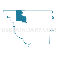
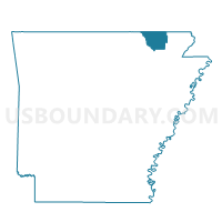
Dalton Voting District, Randolph County, Arkansas
About
Outline

Summary
| Unique Area Identifier | 527935 |
| Name | Dalton Voting District |
| County | Randolph County |
| State | Arkansas |
| Area (square miles) | 42.49 |
| Land Area (square miles) | 42.39 |
| Water Area (square miles) | 0.10 |
| % of Land Area | 99.76 |
| % of Water Area | 0.24 |
| Latitude of the Internal Point | 36.43364680 |
| Longtitude of the Internal Point | -91.18127950 |
Maps

Graphs
Select a template below for downloading or customizing gragh for Dalton Voting District, Randolph County, Arkansas


Neighbors
Neighoring Voting District (by Name) Neighboring Voting District on the Map
- Baker Voting District, Randolph County, AR
- Cedar Bluff Voting District, Oregon County, MO
- Eleven Point Voting District, Randolph County, AR
- Jackson Voting District, Randolph County, AR
- Jane's Creek Voting District, Randolph County, AR
- Myrtle Voting District, Oregon County, MO
- Union Voting District, Randolph County, AR
- Water Valley Voting District, Randolph County, AR
Top 10 Neighboring County Subdivision (by Population) Neighboring County Subdivision on the Map
- Janes Creek township, Randolph County, AR (702)
- Myrtle township, Oregon County, MO (388)
- Water Valley township, Randolph County, AR (289)
- Eleven Point township, Randolph County, AR (277)
- Dalton township, Randolph County, AR (254)
- Jackson township, Randolph County, AR (241)
- Union township, Randolph County, AR (111)
- Cedar Bluff township, Oregon County, MO (91)
- Baker township, Randolph County, AR (55)